


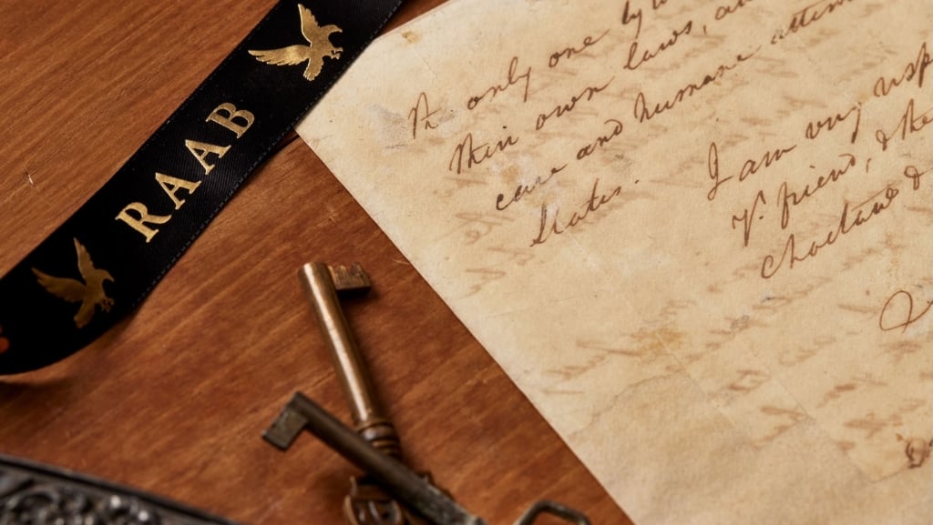


Young George Washington: Rare Warrant Authorizing 18 Year Old George Washington to Do a Survey, With Washington’s Own Docket on the Verso Showing the Work Had Been Done

This authorization for Washington to do the survey, with his docket and statement of completion, is virtually unique; we’ve only found two others coming up in the past 60 years
Between the ages of 17 and 20 (1749-1752), Washington was a practicing professional land surveyor. During that time he made more than 190 surveys, nearly all of them for grants of new lands on the frontiers of Lord William Fairfax’s Northern Neck Proprietary. Lord William Fairfax was Washington’s brother Lawrence’s...


Between the ages of 17 and 20 (1749-1752), Washington was a practicing professional land surveyor. During that time he made more than 190 surveys, nearly all of them for grants of new lands on the frontiers of Lord William Fairfax’s Northern Neck Proprietary. Lord William Fairfax was Washington’s brother Lawrence’s father-in-law, making this a family connection. Lord Fairfax’s son was George W. Fairfax, who served in the Virginia House of Burgesses as a representative for Frederick County. He was a mentor and good friend of George Washington and made opportunities available for the younger Washington when he could. Before July 1749, Washington received a commission from the president and masters of the College of William and Mary appointing him surveyor of newly formed Culpepper County. William Fairfax, who attended council in Williamsburg from March to May 1749, secured the commission for Washington.
Frontier surveying was a lucrative business in Virginia at the middle of the eighteenth century, as swarms of settlers and speculators laid claim to the colony’s western lands, both inside and outside the Northern Neck. Washington’s surveying was done almost entirely in the Shenandoah and Cacapon Valleys of Frederick County, which until 1753 embraced all of the Northern Neck Proprietary west of the Blue Ridge Mountains. It is not surprising that GW chose to survey on the frontier, as on the other side of the Blue Ridge, in Frederick County, people were claiming many vacant tracts in 1750, providing a great deal of lucrative business for a surveyor.
The platting of the surveys and the computation of their acreages occurred after the end of the surveying trip, usually at Ferry Farm or Mount Vernon. The acreage of a survey, once determined, was usually inserted into the field book to be part of the original record, but plats, with a few early exceptions, do not appear in the field books, being drawn only for the finished surveys. All of Washington’s plats were carefully drawn to scale in ink with standard drafting instruments. There is a list of Washington’s professional surveys for the years 1749 to 1752. He stopped surveying in late 1752, when he entered into military service.
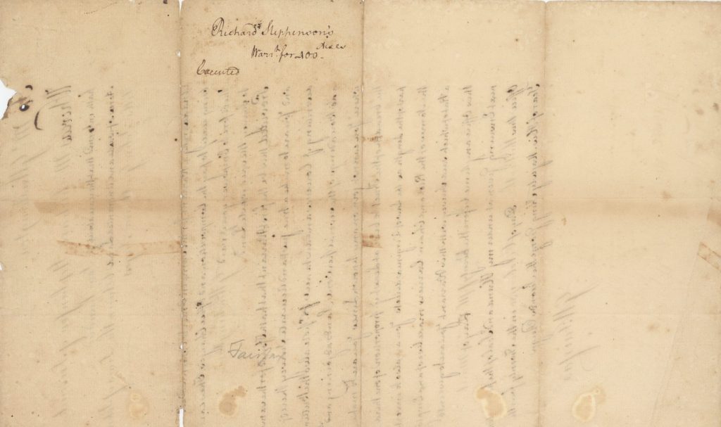
Richard Stephenson was an indentured servant to Hugh Crawford, served out his contract, then marrying Crawford’s widow Honora G. Crawford. Stephenson learned to survey from George Washington. Washington was often a guest in the home of Richard and Honora.
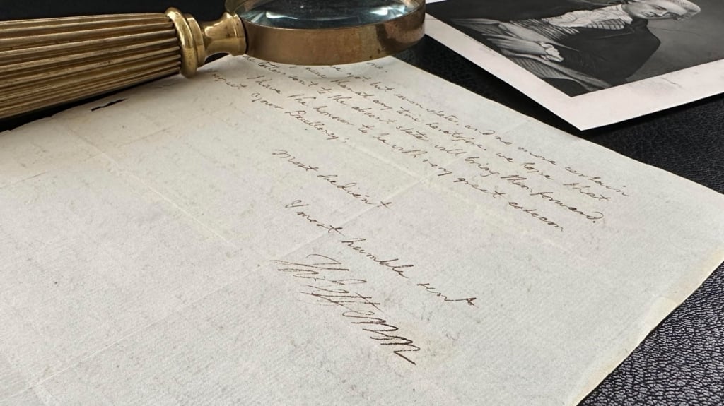
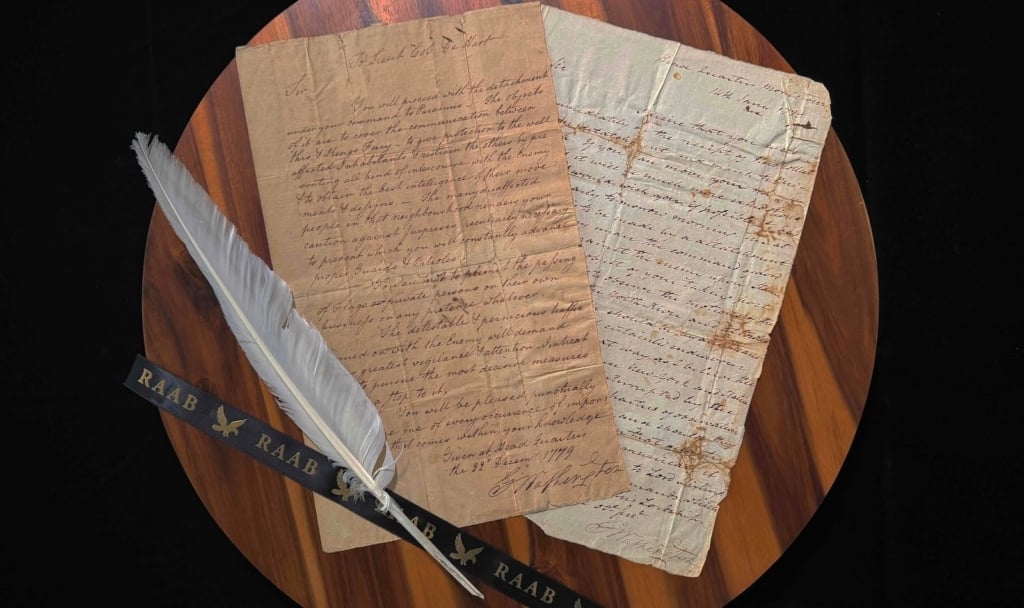
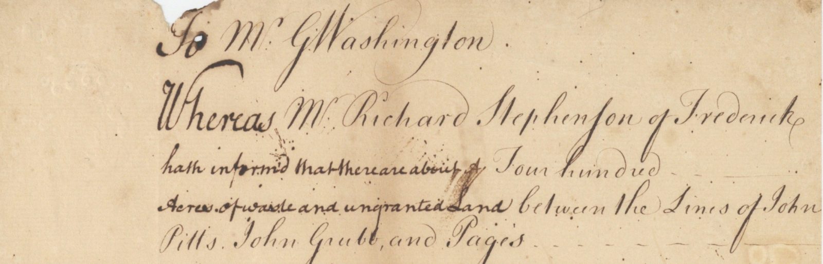
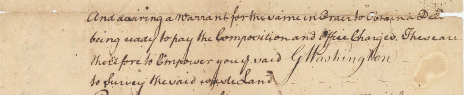
Letter signed by George W. Fairfax, Frederick, Va., October 13, 1750, to George Washington. “To Mr. G. Washington. Whereas Mr. Richard Stephenson of Frederick hath informed that there are about four hundred acres of waste and ungranted land between the lines of John Pitts, John Grubb and Page’s; and desiring a warrant for the same in order to obtain a deed, being ready to pay the composition and office charges. These are therefore to empower the said G. Washington to survey the said wasteland. Provided that this be the first warrant that hath issued for the same. And you are to make a true just and accurate survey thereof, describing the courses and distances from poles; also the butting and boundings of the several persons’ lands adjoining. And where you cannot join on any known lines, you are to make the breadth of the tract to bear at least the portion of one third part of the length as the Laws of Virginia directs.
“You are also to insert the names of the Pilot and chain carriers made use of and employ a plat of which said survey with this warrant. You are to give into this office any time before the twenty fifth day of March next ensuing. Given at under my hand and seal of the Proprietors’ office this thirteenth day of October 1750, in the twenty fourth year of His Majesty King George II’s reign.” Washington was at this date 18 years old. Pitts sold land not only to Stephenson, but also to Lawrence Washington. Grubb was a landowner who used George Washington’s services to help sell it.
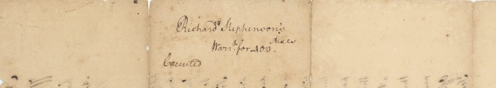
On the verso is the docket, in Washington’s hand. It reads: “Richard Stephenson’s, Warrant for 400 acres”, below which Washington has written “Executed.” This is something of a discovery, as until we obtained this document, the author of the handwriting on the verso had not been identified.
Washington did his surveys and provided the paperwork. Virginia record Book G- 434 confirms Washington doing this survey, stating that land of Richard Stephenson of Frederick County was surveyed by Mr. G. Washington. Adjoining his Patent land. G. W. Farifax, Grubb’s Patent.
Washington’s holograph at age 18 is a rarity, his being the earliest we have ever had. His surveys are rare as well. But this, the authorization for him to do the survey, with his docket and statement of completion, is virtually unique. We’ve only found two others coming up in the past 60 years.

Frame, Display, Preserve
Each frame is custom constructed, using only proper museum archival materials. This includes:The finest frames, tailored to match the document you have chosen. These can period style, antiqued, gilded, wood, etc. Fabric mats, including silk and satin, as well as museum mat board with hand painted bevels. Attachment of the document to the matting to ensure its protection. This "hinging" is done according to archival standards. Protective "glass," or Tru Vue Optium Acrylic glazing, which is shatter resistant, 99% UV protective, and anti-reflective. You benefit from our decades of experience in designing and creating beautiful, compelling, and protective framed historical documents.
Learn more about our Framing Services

