


Meriwether Lewis’s Original Receipt For His Pay For the Lewis and Clark Expedition

An important document in American history, a powerful connection between Lewis and his mission, and a rare autograph of Lewis, whose famed Corps of Discovery opened the American West and set the course for continental expansion
Documents of any sort signed by Lewis are rare; We can only find eleven signed documents and three letters having appeared at public sale since 1975.
The spirit behind the opening of the American West was President Thomas Jefferson. For twenty years he had thought about finding a water route to...


Documents of any sort signed by Lewis are rare; We can only find eleven signed documents and three letters having appeared at public sale since 1975.
The spirit behind the opening of the American West was President Thomas Jefferson. For twenty years he had thought about finding a water route to the Pacific Ocean, and establishing an American presence to the West of the then borders of the United States. That the West was foreign territory didn’t bother Jefferson; his initial efforts occurred while Louisiana belonged to Spain. Indeed, he set about preparing for an exploration before the opportunity to purchase the Louisiana Territory even came along. The consummation of the Louisiana acquisition on April 30, 1803 meant that that the explorers Jefferson hoped to send would remain on American soil until they crossed the Rocky Mountains. To head the expedition, Jefferson chose his young secretary, army captain Meriwether Lewis, who resided in the presidential mansion, and at the President’s behest frequently conversed with prominent figures in politics, the arts and other circles.
Lewis invited his friend Lt. William Clark to share the leadership of the expedition. Both were familiar with the frontier and with Indians through their military service. In commissioning the exploration, on June 20, 1803, Jefferson wrote to Lewis as “Captain of the first regiment of Infantry of the United States of America,” and said “The Object of your mission is to explore the Missouri river & such principal stream of it as by its course and communication with the waters of the Pacific ocean, whether the Columbia, Oregon, Colorado or any other river, may offer the most direct & practicable water communication across this continent for the purpose of commerce.” However, the expedition’s objectives were actually broader; they were partly scientific, partly to open diplomatic relations with Indian tribes, partly to evaluate the land for future settlement, and very much to lay the basis for an American claim to the Pacific Northwest as a way of preempting European nations.
Little was known about western America before Lewis and Clark’s Corps of Discovery. No one had yet blazed an overland trail. In preparation for the historic journey, Lewis studied map making and learned how to fix latitude and longitude. The route of the expedition was carefully planned. The party was to ascend the Missouri to its source, cross the Continental Divide, and descend the Columbia River to its mouth. Lewis left Washington, D.C. to pursue his project on July 5, 1803, but ahead lay almost a year’s worth of preparation. First he picked up arms at the government arsenal at Harper’s Ferry. Then he oversaw the construction of his specially-designed 55-foot keelboat and floated it down the Ohio River. Clark joined him at Clarksville, Indiana, across from Louisville, Kentucky. In the winter of 1803-04 the expedition was assembled in Illinois, near St. Louis. The party consisted of the two leaders, Lewis and Clark; 14 soldiers; nine frontiersmen from Kentucky; two French boatmen; and Clark’s servant, York. On May 14, 1804, the explorers started up the Missouri. On July 30 they held their first powwow, or meeting, with Indians at a place the explorers named Council Bluff. On October 26 they reached the camp of the Mandan Indians. On a site close to present-day Stanton, ND, the explorers built Fort Mandan and spent the winter. It was here that they hired Toussaint Charbonneau, a French interpreter, and his Indian wife, Sacagawea, the sister of a Shoshone chief. As an Indian interpreter she proved invaluable.

After the winter layover, the party continued on up the Missouri River. On April 26, 1805, it passed the mouth of the Yellowstone, and on May 26, Lewis was excited by his first glimpse of the distant Rocky Mountains. However, what they discovered West of the Rockies was radically different from what they had expected. First, the high, arid, and inhospitable Columbia Plateau; and then the awesome Cascade Range, dominated by lofty peaks such as Mounts Adams, Jefferson, St. Helens, and Hood, and penetrated by the precipitous Columbia Gorge. After crossing the Continental Divide late in September, they reached a point on the Clearwater River. From here they were able to proceed by water. They had looked forward to a relatively easy float from the Divide to the Pacific Ocean. On the contrary, they found the roughest water, that Clark called a “swelling, boiling & whorling in every direction.” But then the payoff, they reached the Pacific, having gone from sea to shining sea. On the Pacific shore, near the mouth of the Columbia, they built a stockade, Fort Clatsop. There they spent the winter.
On March 23, 1806, the entire party started back. On June 24, with 66 horses, they began to cross the mountains. On their way, Lewis saw so much game on the river, including buffalo, elk, antelope, and wolves, that he found it “increditable” and resolved “to be silent on the subject further.” But the next day he couldn’t refrain from remarking on the “emence herds” he saw. Once he laid to for an hour to let buffalo cross the river. On August 3 they reached the Missouri. The return through Montana from Travelers’ Rest, via the Yellowstone, took 32 days. The trip upriver between the same two points in 1805, via the Missouri River, had taken 134 days. The party reached St. Louis on Sept. 23, 1806, and there Lewis stopped keeping his journal, writing as the last entry, “In obedience to your orders we have penitrated the Continent of North America to the Pacific Ocean and sufficiently explored the interior of the country to affirm with confidence that we have discovered the most practicable rout which does exist across the continent by means of the navigable branches of the Missouri and Columbia Rivers.”
Their arrival caused great rejoicing, for they had been believed dead. The Corps of Discovery had been gone two years, four months and nine days, and had traveled about 6,000 miles. From St. Louis Lewis made his way back to Washington to personally report to the President. After being wined and dined in Virginia, he arrived there in late December, 1806, bringing the Lewis and Clark Expedition to a close. In one way, their exploration was a disappointment: they proved there was no direct water route across North America. But what they did find changed America’s image of itself. The odyssey of Lewis and Clark has been called “the emblematic American journey.” It led to a re-imagining of the land and its people that transformed the young nation forever, and American settlers and traders soon began to travel over the route they had blazed. They also brought back much new material for map makers and specimens of previously unknown wildlife. The Expedition additionally provided useful support for the United States claim to the Oregon country. In December, 1806, as a reward for his epic journey, Jefferson appointed Lewis governor of Louisiana. However, Lewis was not confirmed by the U.S. Senate until March 1807, and remained in the army as a captain until resigning to take his new post on March 2 of that year.
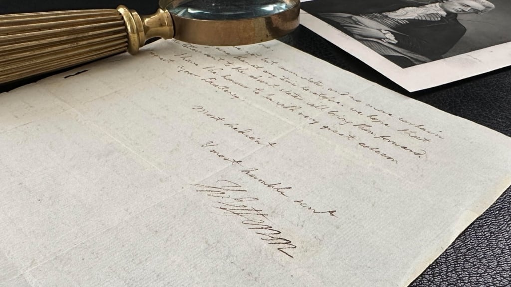
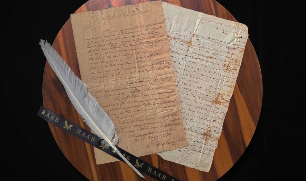
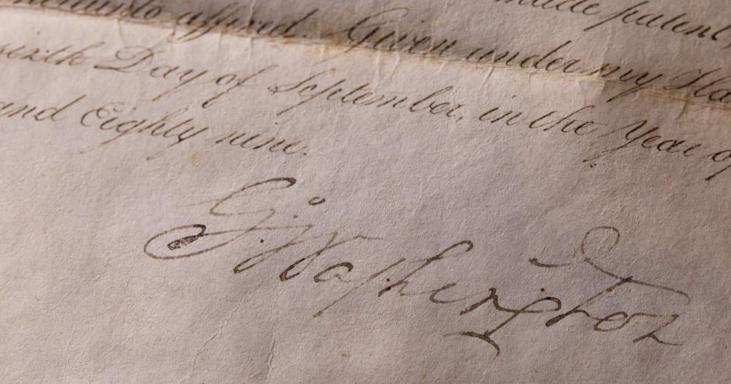
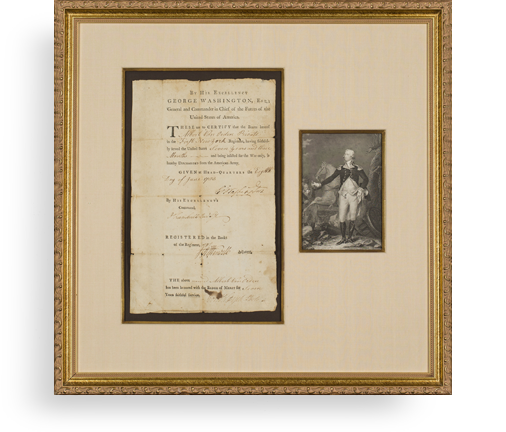
Basic pay for U.S. Army captains at the time was $40 per month at the time, plus a subsistence allowance. For the Lewis and Clark Expedition, Meriwether Lewis received a total of $1,882.58 in pay for 47 months and two days, beginning April 1, 1803, and ending with his resignation on March 2, 1807. He was also allowed $893.64 for subsistence. Manuscript Document Signed, Washington, January 30, 1807. “Received of Caleb Swan paymaster, this 30 day of January 1807, the sum of Two hundred dollars, in pursuance of a warrant from General Henry Dearborn Sec’y of War, No. 1000, being on acct. of pay due me having signed duplicates hereof.” He signed “Meriwether Lewis, Capt., 1st U.S. Regt. Infty.” Caleb Swan was paymaster of the U.S. Army, and would have disbursed pay to army captains as authorized by Secretary of War Dearborn. On the date this document was executed, the pay for February and March, 1807, would not yet have accrued, so Lewis would have had about $1,840 in pay coming to him, all but one month of which he was on the Expedition. This receipt for $200 accounts for almost 1/9 of Lewis’s pay for the Expedition, and represents exactly five months of his salary as a captain. The fact that it is numbered 1000 and others have higher numbers demonstrates that the specific pay Lewis received here, for which this is his receipt, covered the period in which Lewis was on the expedition.

Meriwether Lewis’s signed receipt for his pay for the Lewis and Clark Expedition is an extraordinary piece of American history, and we are proud to present it. As for Lewis, he had but two years to live, dying in 1809. His autographs of any nature are rarities as a result. We can only find eleven signed documents and three letters having appeared at public sale since 1975
In our 30 years in this field, we have seen only two of the original 13 receipts reach the market, all or at least most of the rest being lost or residing in institutions. We handled both of these, and one is no longer in the public sphere. This is the other.
Frame, Display, Preserve
Each frame is custom constructed, using only proper museum archival materials. This includes:The finest frames, tailored to match the document you have chosen. These can period style, antiqued, gilded, wood, etc. Fabric mats, including silk and satin, as well as museum mat board with hand painted bevels. Attachment of the document to the matting to ensure its protection. This "hinging" is done according to archival standards. Protective "glass," or Tru Vue Optium Acrylic glazing, which is shatter resistant, 99% UV protective, and anti-reflective. You benefit from our decades of experience in designing and creating beautiful, compelling, and protective framed historical documents.
Learn more about our Framing Services